Category Archives: Article

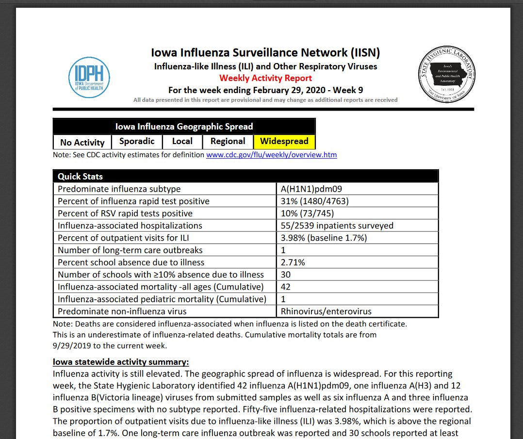
Spring is coming! Time for Nature’s Notebook

As you look out your window you may be noticing that grass is beginning to green up, the lilac bushes are growing new leaves, and a robin is gathering material for a nest. These observations are scientifically termed phenology – the study of cyclic and seasonal natural phenomena relating to climate, plant, and animal life.

As spring begins with many of us social distancing it is a good time to turn our attention towards nature and consider joining the National Phenology Network USA’s Nature’s Notebook program. Nature’s Notebook is a group of volunteer observers (students and citizen scientists) from around the USA who pick an observation site and commit to regularly recording data about it throughout a season. This data can then be used by scientists around the world to better understand changes in climate and plant/animal life around the country.

The Nature’s Notebook website has many useful resources for establishing your observation site as well as ideas for which species to observe. The website also has activities and lesson planning ideas for children and young people. Participating in Nature’s Notebook might be a good adventure during the weeks that school is closed and the days are getting nicer.

Resources:
Phenology Activity Book for Children
Nature’s Notebook – Join a Regional Campaign
Getting Started – Nature’s Notebook in the classroom
Search Plants and Animals to Observe
Learn How to Observe

Additional COVID-19 GIS Mapping Resources for Iowa

Here are several more maps that are helpful for understanding the COVID-19 spread in Iowa.

The State of Iowa has a COVID-19 page: https://coronavirus.iowa.gov/. There is a map of the the confirmed cases statewide. This page has demographic breakdown of the cases by male/female, age cohorts, as well as hospitalization and recovery information.

The Iowa Department of Public Health has a similar page: https://idph.iowa.gov/Emerging-Health-Issues/Novel-Coronavirus. One thing I like about the IDPH page is that they have the number of negative COVID-19 tests as well as the positive cases.


An interesting infographic site that is put out by ESRI called Impact Planning for COVID-19: https://business.maps.arcgis.com/apps/opsdashboard/index.html#/dc74772707d94db9a7d24d30ffdcf36c. This site pulls together demographic data, hospital data, insurance data to give a snap shot of each county around the country.

COVID-19 GIS Map Resources

The geospatial community has been doing a good job of mapping known COVID-19 cases. Having data in a map can often help us with decision making and help keep things in perspective.

ESRI has a COVID-19 GIS Hub which has a lot of great maps, data and applications.

Below are links to three maps that I have found useful:

– John Hopkins University has a map of global cases of the Coronavirus COVID-19 including data about confirmed cases, deaths, recovered, and active cases: https://www.arcgis.com/apps/opsdashboard/index.html#/bda7594740fd40299423467b48e9ecf6

– University of Washington has a more detailed map showing the “infection cases” in the United States. This map has descriptive information about the cases which I have found helpful in understanding more about how the virus and transmission. https://hgis.uw.edu/virus/

– Another map that I have found helpful was produced by 1point3acres, it provides details about each individual case and includes case number, date confirmed, county, and other case notes. https://coronavirus.1point3acres.com/en

The Iowa Department of Public Health also produces a weekly Flu report (Iowa Influenza Surveillance Network) which gives very detailed information about the state of influenza-like illnesses across the state throughout the flu season. https://idph.iowa.gov/influenza/reports

What’s your GIS Story?

A few years ago the Iowa Geographic Information Council (IGIC) asked members to share stories of how members became interested in geospatial technology. Click here to read those stories. It is interesting to read all the different ways people get involved – often through school, other times through a work project, even through life events (hurricanes, Disney World, 4-H, etc.) No matter what path brought you to GIS; we’re glad you are here. Please consider sharing your story on the IGIC website as well.

TELL YOUR GIS STORY

#OSMgeoweek

The OpenStreetMap (OSM) community is also celebrating this week as OSM Geography Awareness Week (#osmgeoweek.) It is a time for teachers, students, community groups, and map lovers, in the US and around the world to join together to celebrate geography and make maps with OpenStreetMap, the free and openly editable map of the world.

Over 132 groups around the world are hosting mapathons to gather people to add to the OSM basemaps. While we aren’t hosting an official event in Ames this week, we do encourage you to get mapping. In a previous post, we suggested ways to connect with the OpenStreetMap community, click here to check that out.

Another way you can do to improve the OSM basemap is to log in and navigate to your local community. Add new developments, new roads, public buildings, parks, and points of interest. It’s always good to make sure your community’s data is fresh and correct.

A Great Week for Geography and GIS

This is another important week for geography and GIS.

November 11-16, 2019 is Geography Awareness Week. It was started over 25 years ago by National Geographic society as a way to raise awareness about the dangerous dificiency of geography in American education and to excite people about geography as a discipline and as part of everyday life. Learn more about Geography Awareness Week from the National Geographic website.

AmericaView’s YouTube videos rock!

Are you new to remote sensing? Are you moving from using ArcGIS Desktop to ArcGIS Pro? Would you like to learn how to better use E-Cognition?

Jarlath O’Neil-Dunne, a professor at University of Vermont and the Director of Spatial Analysis Laboratory has produced an amazing collection of videos which range in scope for those just beginning in remote sensing and GIS to advanced topics and demonstrations.

Here’s the link to Jarlath’s YouTube channel: https://www.youtube.com/channel/UCZb1tQu3rctbyuUQLa1vWnQ. He writes a blog called Letter from the SAL (Spatial Analysis Laboratory.)

AmericaView Mini-grant: Iowa BMP Mapping Project Handbook and Tutorials Available!

IowaView received a mini-grant from AmericaView to create a handbook and tutorials documenting the Iowa Best Management Practices (BMP) Mapping Project. The handbook and tutorials are now available!

Handbook: https://www.iowaview.org/iowa-conservation-mapping-project/

Tutorials:  https://www.iowaview.org/iowa-bmp-project-accessory-data-and-documents-page/