Category Archives: Event

Remembering the 2020 Midwest Derecho

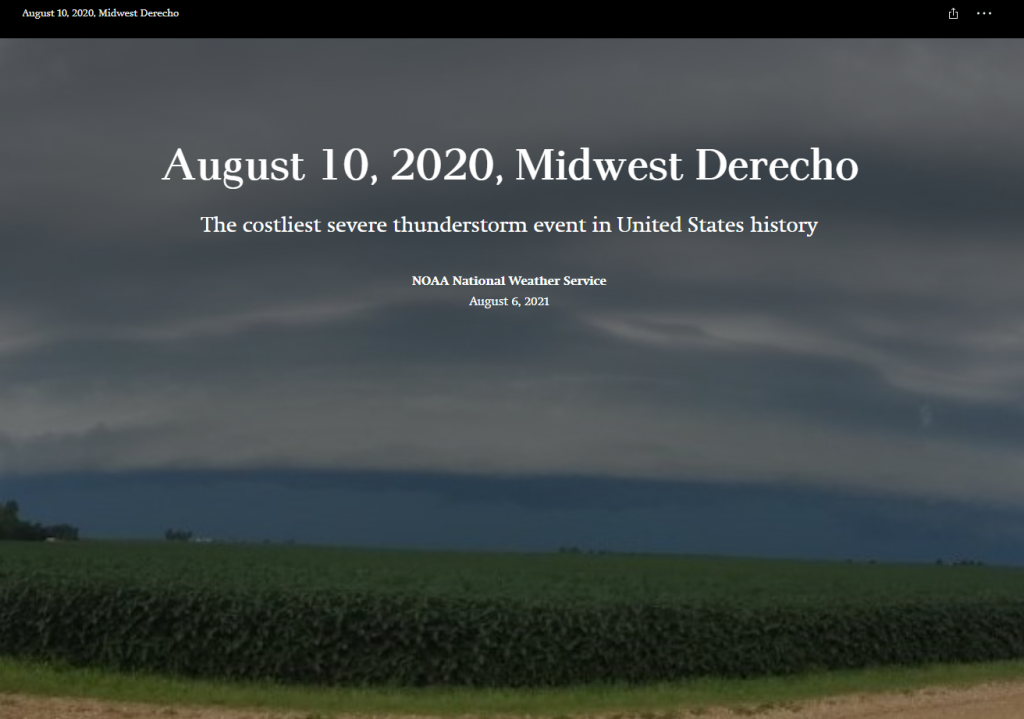
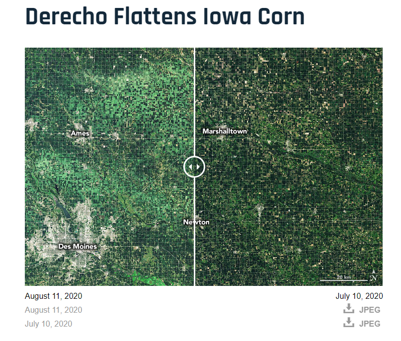
A year ago today a derecho, a series of thunderstorms with hurricane-like winds and heavy rains, struck Iowa with very little warning. The National Oceanic and Atmospheric Administration (NOAA) put together a multi-media story map to tell the tale of this eventful day. Hundreds of thousands of trees were lost or damaged. Homes and buildings were destroyed. Many people lost power for days or even weeks.

Have you visited the NASA’s Earth Observatory? It is a NASA website that helps make satellite imagery relevant to the general public and it is a great place to find images for presentations or use in the classroom. In August 2020, the Earth Observatory featured a comparison of satellite images from July 2020 and August 2020 to show the extent of the derecho damage on Iowa cropland.

Camp Landsat Counts Down to the Landsat 9 Launch

Each week NASA’s Landsat Science team will explore a unique aspect of Landsat earth science (see themes below). Weekly features include Landsat related crafts and games, revisiting each sequential Landsat mission as well a weekly postcard from camp. Stop by each week of camp to explore a new theme.

#ConnectedByEarth – Earth Day 2021!

This year NASA’s Earth Day theme is #ConnectedByEarth. Visit the NASA Earth Day Poster website to watch a short video about the inspiration for the poster and discover the gems hidden within the poster. Download your copy of the poster to learn more about bees and our natural world.

Happy Earth Week 2021!

Earth Day Poster by Brazilian artist – Septo

Here are some ways to celebrate:

A. Get outside – enjoy the beauty of the earth and mark your observations.
Consider joining a citizen science project such as Nature’s Notebook or GLOBE observer Tree Challenge.


B. Explore our beautiful Earth with Ellie Leydsman McGinty’s (UtahView) Earth as Art 4 tour.

C. Learn some new GIS skills with resources from AmericaView members: Google Earth Engine (GeorgiaView), QGIS (WestVirginiaView), or ArcGIS Pro (VirginiaView).

D. Put together an Earth image Puzzle.

Iowa Student Map Contest 2021: Mapping Unique Iowa Features

The 2021 Map Competition for Iowa students is now underway.

Students in grades 4-12 are invited, with their teachers, to participate in this year’s mapping contest sponsored by Esri, the Iowa Geographic Information Council (IGIC), and William Penn University. This year’s theme is Mapping Unique Iowa Features.

Contest Website: https://sites.google.com/site/iowamapcontest/home

Story Maps Website: https://www.esri.com/en-us/arcgis/products/arcgis-storymaps/overview

How to participate: Use the Story Map application to tell a story about a unique feature site using a map and pictures.

There will be $100 cash prize and a certificate for the top five middle school (grades 4-8) and top high school (grades 9-12) map entries. The top entry from each state will be submitted to the national competition hosted by Esri.

Schools must submit their winners to the state for judging by 5 p.m. on Wednesday, May 12, 2021. Iowa GIS professionals will judge the entries so Iowa awards may be announced, and send winning entries on to Esri for the national competition.

OhioView presents Remote Sensing on a Shoestring

Are you interested in learning more about remote sensing but have a limited budget? This February, OhioView will be presenting , “Remote sensing on a shoestring,” and will guide you through how to begin using freely available software and data to perform remote sensing analysis.

Topics for each of the workshops (and their skill level) are as follows:

February 5, 2021, 9am – 1pm (EST):

  • Earth Science Missions Imagery using Google Earth Pro (beginner level)
  • Normalized Difference Calculations with Sentinel-2 using Multispec (intermediate level)
  • Land cover classification of Sentinel-2 images using QGIS (beginner level)

Use this link to register for the February 5 workshop: https://forms.gle/Z269biTar4vU23DU7  The last day for registration for the February 5 workshop will be January 28, 2021.

February 26, 2021, 9am – 1pm (EST):

  • Classification Using Google Earth Engine (intermediate level)
  • Ground validation using the GLOBE Observer app (beginner level)
  • Estimating Evapotranspiration with Landsat using QGIS (intermediate level).

Use this link to register for the February 26 workshop: https://forms.gle/HkRGQ3fn8S81443U6 . The last day for registration for the February 26 workshop will be February 18, 2021.

IowaView Rendezvous at Spirits in the Gardens

On November 1st, IowaView staff participated the “meet-a-scientist” at the annual Reiman Gardens Spirits in the Gardens event featuring a self guided pathway with hundreds of carved pumpkins as well as scientists to meet along the way. During our shift, there were over 250 visitors of all ages. We were able to share posters featuring remote sensing and GIS, which included aerial imagery of Ames and Reiman Gardens dating from the 1930s to 2019. Participants enjoyed seeing change over time as Ames has urbanize over the last ninety years. Staff gave out goodie bags with AmericaView poster, USGS trading cards, and Earth as Art bookmarks and booklets.

Be part of the Global Celebration: Geography Awareness Week 2020!

Join us this week, November 15-21, 2020, as we celebrate Geography Awareness Week. Throughout we will be posting various activities and videos from our friends at OpenStreetMap, National Geographic, and Esri to help you get engage and get informed.

As a way to celebrate GIS Day and OpenStreetMap, we are encouraging everyone to go online either during this week or on GIS Day and contribute to the OpenStreetMap basemap. If you are interested and would like more information about how to get started, please email, Amy Logan.

If this is your first time using OpenStreetMap, sign up for an OpenStreetMap account: https://www.openstreetmap.org/user/new. Then look over this helpful resource from TeachOSM about how to get started and build proficiency with OpenStreetMap: (https://ubique.americangeo.org/wp-content/uploads/2019/09/2_buildings_worksheet_1-2.pdf)

Discover the Mappy Halloween Treasure Hunt and More

ESRI has put together a fun Halloween themed Geography Treasure Hunt that uses their story map technology to test your halloween trivia and world geography knowledge. Good luck.

Another exciting Halloween opportunity for those in the Ames area is Reiman Gardens Spirits in the Gardens event. Participants will enjoy walking through a garden path of hundreds of beautifully carved pumpkins. It is a ticketed event, registration information here. IowaView staff member, Amy Logan, will be at the event on Sunday, November 1st from 5-7pm, discussing remote sensing and GIS and handing out goodie bags of Earthshot trading cards while supplies last.

Mappy Halloween!