The ISU GIS Support and Research Facility and IowaView along with Parks Library will be hosting GIS Day 2024 on Wednesday, November 20, 2024, from 9 a.m. to 12 p.m. in The Catalyst at Parks Library (Room 199) at Iowa State University. This is a come-and-go event so stay as long as you would like. GIS Day is for everyone, from the GIS curious to the GIS user. There will be speakers throughout the morning sharing their research from around campus, information about GIS opportunities and programs on campus, free GIS swag, free food, and a map competition with prizes.
Earth Observation Day 2024 is finally here as it the release of the AmericaView 2024 Earth Observation Day Poster! The poster is following the theme of this year’s Earth Science Week theme, “Earth Science Everywhere”. The front of the AmericaView 2024 Earth Observation Day poster features 6 image themes: agriculture, disaster, forestry, urban land use, water, and wildlife. The back of the poster explains the significance of the images and provides links to 6 themed lesson plans. IowaView was responsible for the disaster management lesson plan.
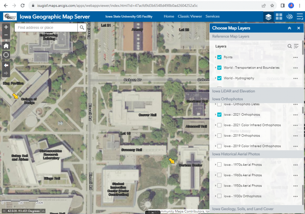
The Iowa Geographic Map Server is a gem of historical and contemporary statewide aerial imagery for Iowa from the 1930s to 2021. It also has many other statewide layers including:
elevation maps (LiDAR and USGS topographic maps),
historical maps (General Land Office survey maps from 1800s, Andreas Atlas, historic topography),
land cover maps (historical and contemporary)
geology (landforms and bedrock)
Here’s your challenge: Zoom into your city or a place of significance to you and discover how it has changed over the years, look at how the land cover changed, challenge yourself to find as many changes as you can.
It’s that time of year again! We are celebrating Geography Awareness Week! November 13-17, 2023
The History of Geography Awareness Week:
Thirty-six years ago, the National Geographic Society advocated to create Geography Awareness Week. Geography Awareness Week is a way to celebrate and raise awareness of geography, both as a discipline and as a part of daily life. The National Geographic Society felt the limited exposure to geography in American education was a dangerous deficiency. Without proper exposure to geography, students are unable to make effective decisions, understand geo-spatial and geo-political issues, or even recognize their impacts as global citizens. — see more at the National Geographic Website
This week we are exploring urban growth in Ames, Iowa. The red areas are showing areas of vegetation that are primarily agricultural in the larger areas, the neon green areas are short grass and trees, the gray color is urban areas, and blue areas are water.
Timelaspse Video of Ames, Iowa 1984 to 2021 – Summer Landsat Images
As you watch the time lapse video notice several things:
The expansion of Ada Hayden (the large lake in the center right of the image.)
How the agricultural land in the center of the images fills in rapidly with development between 2008 to 2021
The increase in permanent water retention ponds in as the city develops.
Many of the red agricultural parcels along Ioway Creek (the left river) become smaller and more developed through the time series.
Compare an image of north Ames, Iowa from 1987 to 2021 – what other urban growth changes can you spot?
Today’s image shows an area in northwest Iowa between Spencer (Clay County) and Emmetsburg (Palo Alto County). The two images on the left are showing water levels in 1990 (typical year) and 2022 (recovering from a drought) compared to 1993 (heavy flooding) and 2008 (flooding). Notice the swollen streambanks and flooding along water bodies in the right images.
This year we are celebrating 50 years of the Landsat earth observing satellite mission. Landsat data helps us observe changes in our communities and environment over time.
To celebrate the Landsat Golden Jubilee, consider taking a virtual visit to Camp Landsat!This summer Camp Landsat is celebrating this exciting anniversary with 5 weeks of programming, celebrating the 5 decades of Landsat’s continuous mission. This week the theme is People and Places.
Enjoy and explore many activities from Camp Landsat including:
Saturday, July 23, 2022 marked the 50th anniversary of the launch of the USGS/NASA Landsat earth observing satellite mission. With the launch in 1972, Landsat has continued its earth observation mission and become the longest continuous earth observing satellite.
Enjoy this video recalling the launch and explaining the beginning of the earth observing satellite mission, Landsat 9 – Part 1: Getting off The Ground: https://www.youtube.com/watch?v=FlRf17Egexo.
We are continuing our celebration of the 50th year of the US Landsat satellite imagery program. This week we are heading to the lake – Clear Lake, Iowa, located in north central Iowa.
Below are four images showing Summer Solstice (6/13/2019), Fall Equinox (9/17/2019), Winter Solstice (12/22/2019), and Spring Equinox (3/18/2019) from Landsat 8. The images are presented in color infrared which shows vegetation in red rather than green for better contrast.
At Summer Solstice things are still greening up while at Fall Equinox the fields are all green and some are beginning to be harvested.
Observe the different states of the lake: open water, snow covered, and frozen.
The topography of the landscape (ie. hills and roughness) are much more apparent with snow on the ground. In the summer/fall images, it all looks flat.