Winner of the Map Category – Mapping My Biking Journey with Distance of Distinct Traveled Paths Created by Atlas Chenxiao Guo from University of Wisconsin-Madison Map Description: This map shows all my biking tracks, including the majority in the US and few Chinese cities. All the circled track maps have the same scale. Each path is counted only once in the distance calculation. For more information Click Here!
Mapping My Biking Journey with Distance of Distinct Traveled Paths Software/Materials Used: ArcGIS Pro; Adobe Illustrator
Winner of the StoryMap Category – Iowa Freedom Rock Tour Created by Trenton Major, College of Agriculture and Life Sciences – Iowa State University StoryMap Description: This Story Map displays the locations of Iowa’s Freedom Rocks and scenic routes. It is designed to help users navigate the Freedom Rock Tour within the state of Iowa.
Iowa Freedom Rock Tour Software/Materials Used:ArcGIS Online, ArcGIS StoryMaps
Thank you again to everyone who participated in this year’s competition!
On Wednesday, November 20, we had a great GIS Day celebration atThe Catalyst in Parks Library. Thank you to library digital scholarship staff for hosting us and providing their expertise.
We had five speakers sharing on different topics:
CollectionBuilder for Historical GIS: an update on the ISU Historical Buildings Project – Erin Ridnour, Digital Scholarship Librarian, University Library
Tillage Detectives: Determining Residue Cover via Satellite – Bryce Pape, Graduate Student and Brian Gelder, DEP and GISF Co-Lead
Library Instruction with ArcGIS StoryMaps – Michael Cummings and Erin Ridnour, Digital Scholarship Librarians
Using Past Slope Failures to Prepare for the Future: A Case Study across the State of North Dakota – Beena Ajmera, Assistant Professor, Department of Civil, Construction and Environmental Engineering
Geospatial Modeling for Regional Trail Planning – Austin Dunn, Assistant Professor, Department of Landscape Architecture
The ISU GIS Facility is hosting our second annual Mapping Masterminds Map Competition. It is open to everyone, everywhere. There are two categories for submissions: 1) Maps and 2) StoryMaps. There are cash gift cards for top prizes. Entries are due Sunday, November 17, 2024. Here is the link to the official website for more details and to submit your map: https://storymaps.arcgis.com/stories/f5f90197f924413080353752f6f89e1e.
The ISU GIS Support and Research Facility and IowaView along with Parks Library will be hosting GIS Day 2024 on Wednesday, November 20, 2024, from 9 a.m. to 12 p.m. in The Catalyst at Parks Library (Room 199) at Iowa State University. This is a come-and-go event so stay as long as you would like. GIS Day is for everyone, from the GIS curious to the GIS user. There will be speakers throughout the morning sharing their research from around campus, information about GIS opportunities and programs on campus, free GIS swag, free food, and a map competition with prizes.
Earth Observation Day 2024 is finally here as it the release of the AmericaView 2024 Earth Observation Day Poster! The poster is following the theme of this year’s Earth Science Week theme, “Earth Science Everywhere”. The front of the AmericaView 2024 Earth Observation Day poster features 6 image themes: agriculture, disaster, forestry, urban land use, water, and wildlife. The back of the poster explains the significance of the images and provides links to 6 themed lesson plans. IowaView was responsible for the disaster management lesson plan.
Next week, IowaView and the ISU GIS Facility will be hosting an Earth Observation Day celebration, on Tuesday, October 15, from 10:00 to 11:30 in Durham 206 as part of Earth Science Week 2024.
Here’s the schedule:
10:00 – 10:30 Dr. Antonio Arenas, Civil Construction & Environmental Engineering Topic: Google Earth Engine and Open ET (Evapotranspiration)
10:30 – 11:00 Dr. Brian Gelder, Agricultural And Biosystems Engineering, ISU GIS Facility Research Lead Topic: LiDAR Processing via ArcGIS and PDAL (a Python extension for translating point cloud data)
11:00 – 11:30 Bryce Pape – Graduate Student, Community and Regional Planning Topic: Google Earth Engine and Agriculture Residue Cover
We will also provide snacks (a cupcake cake) and Earth Observation Day swag including booklets, posters, and trading cards. Please come and go as you need to. We look forward to seeing you there.
The ISU GIS Facility will be hosting the 3rd annual geospatial summer workshop for K-12 teachers and pre-service teachers in Ames, Iowa on July 17 – 18, 2024. This workshop will show many geospatial tools and applications from the Esri ecosystem as well as Google Earth, OpenStreetMap, AmericaView, and others. Teachers will get to see a variety of map tools and exercises that they can bring into current lessons. We will explore resources available at local, state, and national levels. Each participant will make a StoryMap to use in their classroom. Teachers can sign up for graduate or continuing education credit. Please email Amy Logan with any questions.
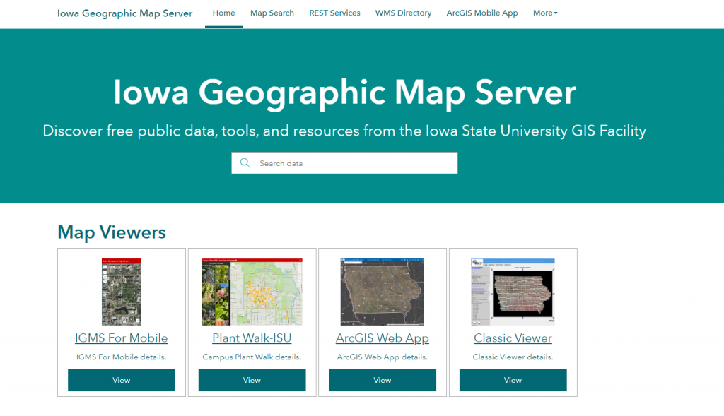
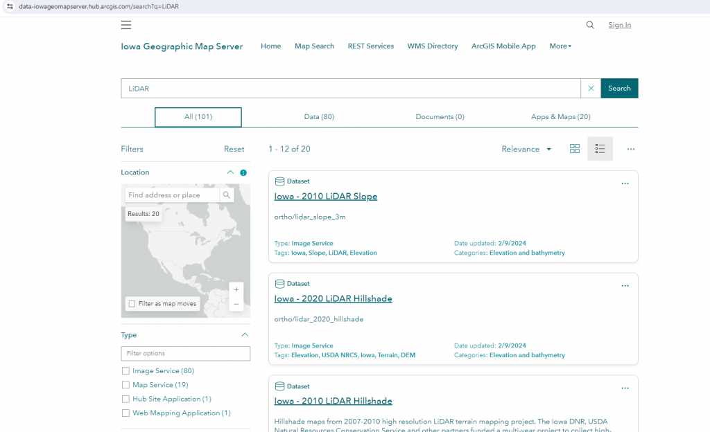
This spring theIowa Geographic Map Server (IGMS) has released new and improved metadata as part of the IGMS data hub site. The upgraded metadata allows for better searching capabilities of IGMS data layers and also provides users with more documentation about the layers that they are viewing and using. Follow the link below to search and explore. Thank you Michaela and Gregg for this new product!
A Quick Look into Two Worlds: Video Games and GIS By Wael Alhaj
Imagine you’re playing your favorite video game, exploring new territories, or maybe you’re looking at a map, trying to find a place you’ve never been. Sounds pretty different, right? Actually, not as much as you might think! Video games and Geographic Information Systems (GIS), another term for map-making and analyzing, share more in common than you’d guess. Video games are all about fun and adventures, while GIS sounds like serious business with maps and data. But if we look more in depth, they are close related in the world of technology.
Both video games and GIS are big on creating spaces, whether it’s a fantasy land in a game or a detailed map of your city. In video games, you might roam around imaginary places or ones that look similar to the real life. GIS, on the other hand, is more about mapping out the real world, but sometimes it uses simple and easy to understand pictures instead of super detailed ones. Both are all about giving you a sense of space one for fun, the other for facts and figures.
Making Things Look Real
As game players we ask, how do some games look almost like real life? This is called “visual realism” and it’s pretty impressive in today’s games. GIS does something similar, but instead of creating life-like world and landscapes, it shows real-life information in a way that makes sense by converting the data into a colorful map. Games go for the impressive appeal and eye-catching goal with graphics, while GIS tries to make complex info easy to get.
Handling Loads of Data
Video games and GIS deal with a lot of details. Games keep track of everything in their world such as places, objects, characters. As Same as in GIS, which combines location and spatial info with all sorts of other data. They both handle a ton of different kind of information, showing us how to manage and use big sort of data in different ways.
Scripts and User-Friendly Features
Both video games and GIS use some smart tricks behind the scenes. They’ve got algorithms for figuring out space related stuff, like how to find the best path from “A” to “B”. Games focus more on making everything interactive and fun, with everything happening in real-time. GIS concept is more about analyzing space and showing data in a fixed way. But deep down, the theories, codes and scripts they use is pretty similar.
Challenges and Possibilities
Video games and GIS can learn a lot from each other. Games are always pushing the limits of making things look real and keeping players engaged and hooked, which could be great for GIS to make maps more interesting and interactive. On the flip side, GIS focus on getting every detail right and accurate could help games, especially when a developer wants a game to mimic the real world.
So, the intersection where video games and GIS meet shows us how two areas we thought were worlds apart can actually help each other out. As tech keeps evolving, we’ll probably see more of this mix and match, leading to even great results in both gaming and the map-making industry. It’s all about being creative with space, whether it’s for fun, learning, or visualize facts and information.
References
For all the reasons mentioned above, GIS industry, including companies like ESRI, is actively working on developing various plugins and tools for game engines such as Unity and Unreal Engine. These tools are designed to help game developers and designers to create realistic world maps and 3D content using GIS data. For further reference, you can explore these links: ArcGIS for Unity (https://developers.arcgis.com/unity/) and ArcGIS for Unreal Engine (https://developers.arcgis.com/unreal-engine/). Additionally, the paper “Videogames: the new GIS?” by Ifan D H Shepherd & Iestyn Bleasdale-Shepherd (https://www.researchgate.net/publication/228577009_Videogames_the_new_GIS), offers valuable insights and is a great resource while exploring this topic.