A Calendar Full of Exciting, Engaging April Events

Happy Earth Month! This month is full of lots of exciting and engaging events for you to participate in. Here are some coming up soon:

What: VIRTUAL EVENT: ASPRS GeoBytes Webinar: A History of the Landsat Program presented by Ellie Leydsman McGinty This is going to be a fantastic opportunity to learn about some of the stories behind how the Landsat program became what it is today and some of the people that made it happen.
When: 4/8/22 @ 12pm-1pm (Eastern)
Registration (free): https://my.asprs.org/ASPRSMember/Events/Event_Display.aspx?EventKey=GB20220408&WebsiteKey=9126ee3f-e9e1-43bd-a00c-0cfa63182579
What: VIRTUAL AND IN-PERSON EVENT Virginia Tech Office of GIS and Remote Sensing Research Symposium
We have an exceptional panel of speakers on hand this year representing Duke University, NASA (Emerita), and Virginia Tech. Another highlight of the Symposium, is the student poster session & web map app showcase with over 35 undergraduate and graduate student posters on full display!
When: 4/8/22 @ 12pm-3:30pm (Eastern)
Registration (free): https://virginiatech.zoom.us/webinar/register/WN_n0l1pRCTTSWgDeP7Jwx47Q
What: VIRTUAL AND IN-PERSON EVENT Iowa Technology and Education Connection (ITEC) Conference
ITEC is hosting the annual conference on April 13-14. Join fellow Iowa educators at the state’s premier Tech Ed event! IowaView staff will be presenting on April 14 at 1:15 -2:05pm – Spreading the Mapping Bug: Sharing Geospatial Resources, Ready-to-Go Curriculum, and Mapping Activities for Teachers to Use Tomorrow and Integrate into Their Lessons. Great for student engagement. Many of these materials align with core standards and resources include interactive maps and apps available immediately.
When: 4/14/22 @ 1:15-2:05pm
Registration: https://www.itec-ia.org/conference-registration-details/
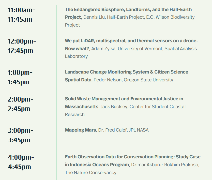
What: VIRTUAL EVENT GeoTech Center – Earth Observation Day
When: 4/20/22 @ 11am-4:45pm (Eastern)
Registration (free): https://storymaps.arcgis.com/stories/02d5fc3ded704f958fb1aa96d9e125bf
For even more events check out the IowaView Jobs and Other Opportunities Page.


